1. Nocturnal Meso-Beta Basin and Katabatic Flows on a Midlatitude Island
Several mesoscale simulations for the island of Majorca, Spain, in the western Mediterranean Sea are used to study the nocturnal system of winds under weak-synoptic pressure gradients. A very high vertical resolution (3m close to the surface and gradually stretched with height) is used to characterize with large detail the thin circulations close to ground, namely, basin and katabatic flows. Two nested domains are taken at 5 km and 1km horizontal resolutions (see Figure 1.1). Further details are found in Cuxart et al., 2007; Jiménez et al., 2008).
During the night, the Tramontana Mountain Range allows the creation of a zone of very weak winds over the center of the island where local winds can develop (Figure 1.2). Katabatic flows converge to the valleys where they interact with a cold pool, which is advected slowly to sea by the land–sea night-breeze effect combined with a topographic forcing. The model outputs are verified using surface weather stations (Figure 1.3) and satellite images (Figure 1.4). It is difficult to verify the model outputs under weak-pressure gradient conditions and clear-skies since the local effects play a very important role (Figure 1.5). The katatatic generated over the slope from the Randa mountain to the Palma Airport is further analysed (Figure 1.6).
Despite its relatively small size, this mid-latitude island has a complicated flow pattern in the night-time, mostly related to its topographical characteristics. It is found that the different relevant scales (island, basin, and slope) generate flows that interact in a complex manner. When the synoptic wind is weak, the island becomes an area where locally generated winds prevail.
|
|
| a) Outer domain: horizontal resolution 5 km x 5km | b) Inner domain: horizontal resolution 1km x 1km (125 x 100 gridpoints) |


Figure 1.1: (a) Outer and (b) inner domains of the run.
| (a) |  |
| (b) |  |
| (c) | 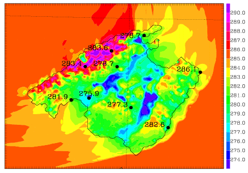 |
Figure 1.2: (a) and (b) Wind direction and speed (in m/s) and (c) 2m-temperature (K) at 0000 UTC on 29th April 2005. In dots the location of the automatic surface weather stations from AEMET and their corresponding measured value aside.


Figure 1.3: Verification of the modelled 10m-wind speed and 2m- temperature for the surface station located in the Palma de Mallorca Airport for the night from 28th to 29th April 2005.


Figure 1.4: (Left) land surface temperature (in K) obtained from the model and (right) the one derived from the NOAA satellite image at 2130 UTC on 28th April 2005.


Figura 1.5: The same as Figure 1.4 but at 0330 UTC on 29th April 2005.


Figura 1.6: Observed and simulated time series of the temperature at different locations: Palma de Mallorca Airport (10km inland), Lluc (small and closed valley in the Serra de Tramuntana), Portopí (at the seashore) and Porreres (middle of the Campos basin).
 |  |
|
| (a) | (b) | (c) |

Figure 1.7: (a) horizontal wind velocity and direction at 30 m AGL over topography (in m). (b) Vertical cross-section of wind speed (in m/s) and (c) potential temperature (in K) following the line Randa-Airport in Mallorca. All figures are plotted at 0000 UTC on 29th April 2005.